


Ousado lurking

The northern Pantanal from an eagle's-eye view
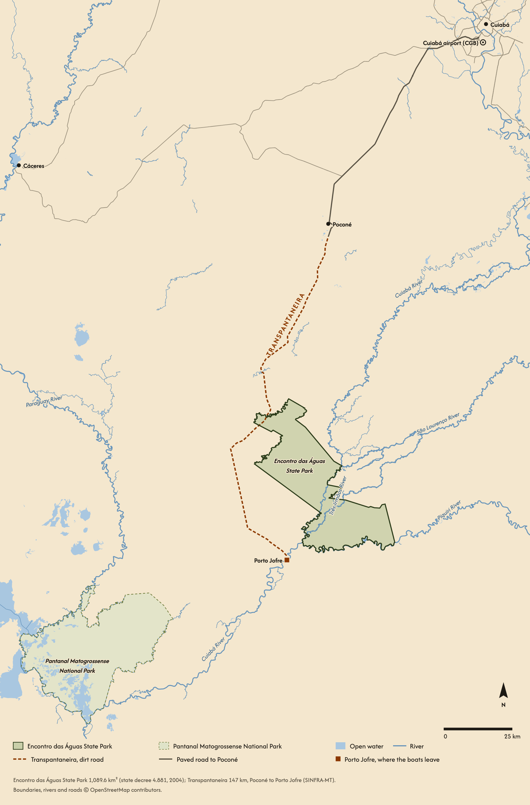
The Pantanal is the largest tropical wetland on earth, between 140,000 and 195,000 square km of seasonal floodplain, mostly in the Brazilian states of Mato Grosso do Sul and Mato Grosso, with parts in Bolivia and Paraguay. This map shows its northern end, in Mato Grosso, where the jaguars are watched from boats. The nearest airport is Cuiabá (CGB). From there it is about 100 km of paved road to the town of Poconé, where the Transpantaneira begins: 147 km of dirt road and about 120 bridges, most of them wooden, south to Porto Jofre on the Cuiabá River. The road ends there, and the boats leave.
Just upstream of Porto Jofre lies Encontro das Águas State Park, 1,089.6 square km, created in 2004. Its name means the meeting of the waters: the Cuiabá, the Piquiri and the São Lourenço rivers come together here, and the boats work these rivers and their side channels, the Três Irmãos among them.
Here are some facts and notes about the Pantanal
The Pantanal works nothing like a tiger reserve. You photograph from a boat rather than a vehicle, which means eye level with the animal, no dust, and the freedom to reposition for the light in seconds rather than minutes. It is also the most reliable place to photograph a wild jaguar: the cats here are used to boats and hunt the river margins in daylight.
Rain falls mostly between November and March, when the rivers rise by several metres and spill across the plains. In the dry season the water draws back into the rivers, and the jaguars rest and hunt along the banks, where the boats can reach them.
The Pantanal holds an estimated 4,000 to 6,000 jaguars. Around Porto Jofre, the Jaguar ID Project's count of jaguars used to boats rose from 29 in 2013 to 130 in 2023.
About 99% of the Pantanal is privately owned, most of it farmland and cattle ranches. The UNESCO World Heritage site, the Pantanal Conservation Area, lies about 150 km down the Cuiabá River from Porto Jofre: Pantanal Matogrossense National Park, created in 1981, and three private reserves beside it. The wider Pantanal became a UNESCO biosphere reserve in 2000.
The Transpantaneira was meant to run on to Corumbá, far to the south. The wet ground and concern for the wetland stopped its construction at Porto Jofre, and the road has ended there ever since.
In 2020, fires burned about 31% of the Pantanal and most of Encontro das Águas State Park, and at least 15% of the Pantanal burned again in 2024.
Not only jaguars
Meet the other denizens of the wetland: giant otters, capybaras, yacare caimans, marsh deer, tapirs, giant anteaters, ocelots and yellow anacondas. Then there is a bird list of over 460 species, from hyacinth macaws and jabiru storks to toucans and kingfishers.
The Pantanal at a glance
- Country
- Brazil
- Regions we work
- Northern Pantanal (Porto Jofre and the Transpantaneira); Southern Pantanal (Mato Grosso do Sul)
- Nearest airport
- Cuiabá (CGB), about 100 km from Poconé
- The road in
- The Transpantaneira (MT-060), 147 km of dirt road from Poconé to Porto Jofre
- Protected area
- Encontro das Águas State Park, 1,089.6 square km
- How you photograph
- From boats on the river systems
- Terrain
- Rivers, seasonally flooded grassland and riverside forest
- Best time to visit
- The dry season, roughly July to October
- Best for
- Jaguar photography, birders, offbeat explorers
The Pantanal, photographed
Every frame here was taken in the Pantanal, on our trips.


Frequently asked questions
When is the best time to see jaguars?
The dry season, roughly July to October. By then the floods have drained back into the rivers, and the jaguars rest and hunt along the banks.
How far is Porto Jofre from Cuiabá?
About 250 km by road: about 100 km of paved road to Poconé, then 147 km of dirt on the Transpantaneira.